Canadian Store (CAD)
You are currently shopping in our Canadian store. For orders outside of Canada, please switch to our international store. International and US orders are billed in US dollars.


You are currently shopping in our Canadian store. For orders outside of Canada, please switch to our international store. International and US orders are billed in US dollars.
NEW RELEASE: Maps and Memes offers a critical introduction to Canadian cartography and counter-mapping in indigenous, legal, and educational contexts. Exploring alternative conceptualizations of maps and mapmaking, the book theorizes the potentially creative and therapeutic uses of maps for indigenous healing from the legacies of residential schools and colonial dispossession.
In this special guest post, author Gwilym Lucas Eades introduces the idea of place-memes and its relevance to indigenous communities.
 Humans have always made maps. Travelling to work each day, heading home for the holidays, or just going out for a stroll, all involve ancient mapping structures. Our maps are our dreams too when we make plans or figure out ways to get to where we want to be in life far in the future (or just for today). Maps and Memes explores how these themes relate to what it means to be indigenous in Canada.
Many indigenous place-names are ancient, from before living memory, and are a fact of life in Canada, with some of our best-known toponyms derived from aboriginal language (including our capital city). Less well-known to most people are the names that have always been there, spread out across the land, a living density of reference, meaning, and intergenerational knowledge that links up routes, places, and areas of interaction between humans, other animals, and their environments.
It was deceptively simple to come up with the idea of the place-meme. The components for the concept were partly there in writers whose books I admire including Keith Basso’s Wisdom Sits in Places (University of New Mexico Press) and Thomas F. Thornton’s Being and Place Among the Tlingit (University of Washington Press). These authors speak of the intergenerational nature of structures of place and space, of how place-based information is handed down in the form of stories and performed journeys from elders to youth over long periods of time. On the other hand, the place-meme combines complex ideas about evolution, geographic information, and indigenous knowledge that are not immediately obvious.
Place-memes are more than (named) places. They are meaningful, linked, sets of places with rich information attached in the form of stories, maps, names, and images that are handed down through time. Think of a route that is planned in advance, plotted on a map with a line connecting the start and end points of the journey. Imagine the difference between seeing such map for the first time without ever having physically traversed the route, and compare this to the experience of having gone somewhere before. How much more meaningful information we have in our brains (and our bodies) after the fact of arrival at the destination! Now imagine knowing a route so well that you can make the journey without any written map, and can describe in detail each nook and cranny of the path, including what plants grow there, and the kinds of birds or animal one will see along the way, in exquisite detail.
This is what indigenous place-naming, mapping, storytelling, and, indeed, Maps and Memes are all about. Our most important maps are already there, embodied in ancestral recounting of spatial structures performed by bodies, brains, and feet.
There is a risk that place-based knowledge of, for example, Cree and Inuit elders will be lost if language embodied through life on the land and its meaningful referents pass away without youthful performance of place-memes. I was lucky to be included in commemorative activities in northern Quebec including kaachewaapechuu (going offshore) in Wemindji Quebec. I experienced first-hand the healing power of returning to the land, travelling with children, youth, and elders on a three day walk back to an old village site where ancestors lived on James Bay.
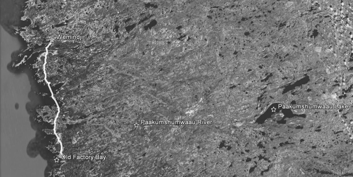
Figure 2.6 Kaachewaapechuu (Google Earth)
Walking across snowy bays with maps and a handheld GPS with Wemindji Cree fellow-travellers, I heard about the old days. At the same time, children regaled me with stories about learning to hunt and interact with the land during that long walk across the wintery northern Quebec landscape. This book is about exploring how maps, GPS, and mapmaking activities offer therapeutic new ways for re-connecting youth (and elders) with the land, with insights applicable to indigenous and non-indigenous communities alike.
More about kaachewaapechuu in this EXCERPT from Maps and Memes:
Kaachewaapechuu represents a place-meme for preserving communal memory about life in the past, in ways more in tune with nature, but also through very hard times introduced both by nature (i.e. variability in game availability) and by rapid cultural and economic changes from outside. It follows the same path every year, cutting across points, headlands, and peninsulas, and making straight traverses over frozen bays. Elders note that in traditional times the journey was often a solitary one that could be completed in one day, as opposed to the contemporary three-day journey. Equipment was lighter then and also, since the trip was made more frequently, the travellers were more experienced, allowing them to make better time.
This route is transmitted from elders to youth by performing the commemoration in the same way each year and by participating in the walk in close proximity to each other, telling stories along the way. But the meaning of the journey has changed in recent years. For example, I brought a GPS receiver and utilized it from time to time, stopping in boreal forests full of snow-covered black spruce or on broad white expanses of frozen bays to look at the data on the screen. Before this trip, the Cree place-names database had been loaded onto the GPS in order to verify names as we moved through places associated with them. The presence of GPS among the company of travellers sometimes created discussion but more often elicited the question “How far is it now?” The GPS device thus replaces an internally performed function with an external inscription to aid in the navigation of distances and to adjust behaviour, such as speed and bearing, accordingly. Cognitively, the GPS acts as a bit of “extended mind” (Rowlands, 2010) through the writing down (on a screen) of relevant bits of information that save our brains from having to do that same work. The work performed by bodies or, more precisely, by brains housed in bodies, is transferred to a battery-powered device that can be trusted, because everyone in Wemindji knows about GPS. Many tallymen (and others) use them, for example, when fishing or when lost in fog. As for helping in the preservation of place-memes or the performance of commemorative activity, it was the feeling among the group that the presence of GPS wouldn’t hurt, and it seemed to be treated almost like a small pet or another slightly odd participant, or even actor, in kaachewaapechuu that year.
To learn more about Maps and Memes, or to order a copy online, click here.
For media requests, please contact Jacqui Davis.
McGill-Queen’s University Press in Montreal is on land which long served as a site of meeting and exchange amongst Indigenous Peoples, including the Haudenosaunee and Anishinabeg nations.
No comments yet.